HoudahGeo是一款为自己的图像和照片添加地理位置信息的软件,是一款专为Mac OS X设计的照片地理编码和地理标记解决方案。该软件能够将将元数据保存到行业标准的EXIF,XMP和IPTC元数据标签中,而无需重新压缩或降低质量,为图像添加各类地理位置信息。
[HoudahGeo 在官网售价 39.00 美元]
HoudahGeo 6.0.1 Mac 破解版 介绍
HoudahGeo:知道你在哪里拍的照片!HoudahGeo是专为Mac OS X设计的照片地理编码和地理标记解决方案。它可以将照片“固定”在拍摄位置。就像支持GPS的相机一样,HoudahGeo可以在图像文件中存储纬度,经度和高度信息。HoudahGeo将行业标准EXIF,XMP和IPTC标签写入JPEG和RAW图像,而无需重新压缩或降低质量。
HoudahGeo is a photo geocoding and geotagging tool. It tags photos with location coordinates and names.
HoudahGeo is used by travelers and professionals alike. Some use location information to organize and find photos. Others need to add GPS coordinates to photos in order to assess roadwork damages, to record wildlife sightings or to document environmental damages.
HoudahGeo writes EXIF, XMP and IPTC geotags to JPEG, RAW, and XMP sidecar files. Just like a GPS-enabled camera, HoudahGeo records latitude, longitude, and altitude information right to your image data file. Don't have a GPS device? No problem! Just drop a pin on the map where you took your photo and HoudahGeo will tag it with the correct location. HoudahGeo is the only application that can both write future-proof GPS tags to original images and add locations to photos in the Apple Photos, iPhoto and Aperture libraries.
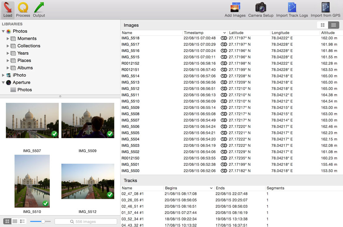
Geotagging with HoudahGeo follows an easy 3-step workflow: load, process, and then output.
- Start by loading photos into a HoudahGeo project. Optionally add GPS track logs
- Use the built-in map to assign or adjust photo locations. Use reverse geocoding to add city, state / province and country names
- Write location information to the original image files. Export the project for viewing in Google Earth or Google My Maps. Upload to Flickr
Features
- Automatic geocoding using GPS track logs
- Geocoding using reference photos taken using iPhone or a GPS camera
- Geocoding without a GPS. Use the built-in map to double-check, adjust, or assign locations to your photos
- Reverse geocoding fills in city, state / province and country names
- Writes GPS data, location names, title, description and keywords to EXIF, XMP and IPTC tags
- Works with JPEG as well as a large number of RAW file formats. It also supports XMP sidecar files.
- Integrates with Apple Photos, iPhoto, Aperture, and Adobe Lightroom Classic
- Notifies Apple Photos (2.0 or newer), iPhoto or Aperture when places information has been updated
- Create Google Earth KML and KMZ files. View photos "pinned" along the path travelled
- Publish photos and KML files to Dropbox. Share images on a map
- Upload geotagged photos to Flickr
HoudahGeo 6.0.1 Mac 破解版 下载
[download id="18121,18122"]